Location Allocation Analysis: Maximizing Coverage
Analyse av stedstildeling: Maksimering av dekning
Project Overview
Prosjektoversikt
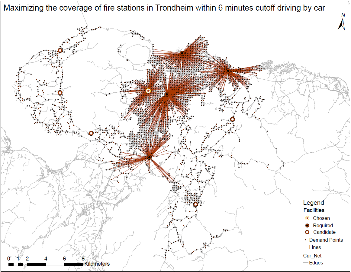
This project investigates how fire stations in Trondheim can optimize their coverage within a 6-minute driving time cutoff. The goal is to increase the overall percentage of the population served by existing facilities and propose a new fire station location to reach at least 80% coverage.
Using a location-allocation model in ArcGIS Pro, the population points within a 6-minute drive of the current four fire stations are identified. Then six candidate sites tested to find the single best addition that maximizes coverage, raising overall coverage from about 70% to nearly 80%. Then the model identify the best candidate to achieve maximum coverage within a maximum response time of 6 minutes. The result is shown in the above map.
Dette prosjektet undersøker hvordan brannstasjoner i Trondheim kan optimere dekningen innenfor en 6-minutters kjøretid. Målet er å øke prosenten av befolkningen som dekkes av eksisterende stasjoner, samt å foreslå en ny beliggenhet for å nå minst 80% dekning.
Ved å bruke en lokasjonsallokeringsmodell i ArcGIS Pro, peker befolkningen innenfor en 6-minutters kjøretur av dagens fire brannstasjoner er identifisert. Deretter testet seks kandidatnettsteder for å finne det beste enkelttilskuddet som maksimerer dekningen, og øker den totale dekningen fra omtrent 70 % til nesten 80 %. Deretter identifiserer modellen den beste kandidaten for å oppnå maksimal dekning innen en maksimal responstid på 6 minutter. Resultatet er vist i kartet ovenfor.
Tools Used
Verktøy brukt
ArcGIS Pro, Location Allocation Model, NVDB Road Network
Project Date
Prosjektdato
2023
Project Type
Prosjekttype
GIS & Network Analysis
GIS- og nettverksanalyse